


")


TAHLEQUAH, OK – The Cherokee Nation has published official, updated demographic maps reflecting the growing diversity among the tribe’s more than 460,000 citizens and where they live across the country. This marks the first time the demographic maps of Cherokee citizenship have been updated and shared for the public in more than a decade.
The new maps, available to view online at https://cherokee.org/about-the-nation/maps, were created by a mapping work group established by Principal Chief Chuck Hoskin Jr. and Deputy Chief Bryan Warner in 2024, with the help of the Office of the Secretary of Natural Resources GeoData team.
“The Cherokee Nation is a growing, thriving Nation with more than 460,000 citizens living around the world,” said Chief Hoskin. “Understanding where our citizens live is crucial in how we maintain connection to our citizens and continually improve the services we provide them, including access to culture and language activities. These new maps replace outdated maps that were last updated in 2013 and provide us with a clear look at Cherokee citizen population diversity. We are proud to have these available not only for official Cherokee Nation use, but for access by the public and our many Cherokee community groups, which may find them helpful in connecting with Cherokee citizens in their region.”
According to the updated demographic maps, Oklahoma continues to be home to the highest number of Cherokee citizens, with more than 283,000 – or over 60 percent – residing in the state. Texas has the second-highest population with more than 29,400 citizens, or 6.3 percent, followed by California’s nearly 28,000 citizens. Arkansas, Kansas, Missouri, Washington State, Arizona, Colorado, Oregon, Florida and New Mexico round out the list of the top 12 states by percent of population.
“Cherokee citizens really do live in every corner of the country and all around the world,” said Deputy Chief Warner. “We work hard every day to keep them connected to their tribe, so it’s important to establish a consistent method for updating maps and providing them to Cherokee Nation departments and to the public. Our mapping work group was tasked with updating our demographic maps, and looking at ways to ensure we keep them updated consistently moving forward.”
New maps include the top 12 most populous states, as well as maps depicting Cherokee Nation reservation and contiguous county population, and a map depicting citizenship population density by county among the 12 largest states for citizenship.
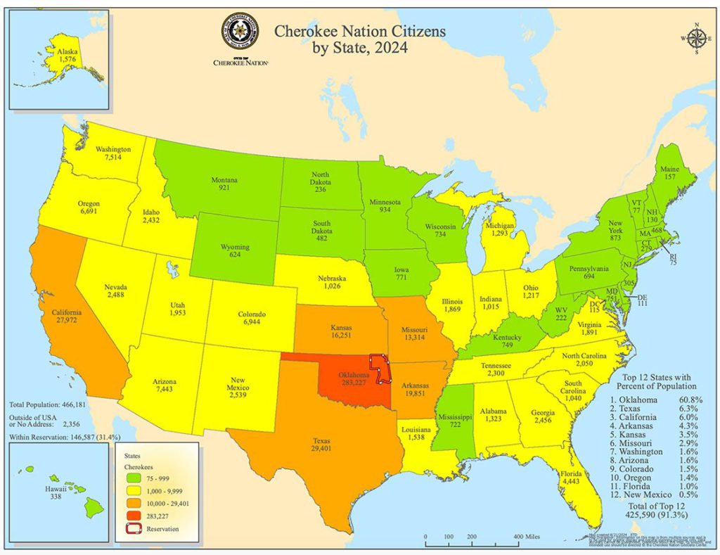
Earlier this year, Chief Hoskin and Deputy Chief Warner created a mapping work group to update and expand maps available for the public and for internal use to aid in policy making. They requested that the mapping work group update official Cherokee Nation demographic maps every odd-numbered fiscal year to ensure changes in population are properly reflected and made accessible to the public. The group is also tasked with producing a number of additional maps in the future, including maps that pinpoint first-language fluent Cherokee speakers, and others.
The public can also access new Council of the Cherokee Nation District maps online by visiting https://legislative.cherokee.org. The new Council districts are a reflection of legislation signed by Chief Hoskin earlier this year redistricting the tribe’s legislative Council district map based on major population changes over the past decade. The Council spent months examining the need to redraw the tribe’s 15 on-reservation Council districts based on the population changes since the last redistricting effort in 2013.
The new Council maps will be in effect for the 2025 mid-term Council elections, which will be held in June 2025 for half of the tribe’s legislative seats.
